


Tour du Mont d'Alambre 07-09-2020

nolsim
User
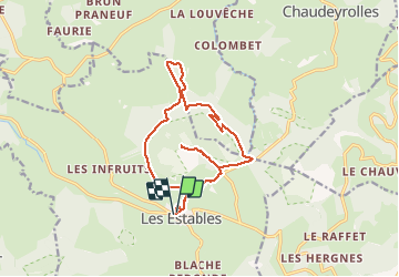

Length
15.5 km

Max alt
1638 m

Uphill gradient
512 m
Km-Effort
22 km

Min alt
1344 m

Downhill gradient
519 m
Boucle
Yes
Creation date :
2020-09-07 06:39:37.351
Updated on :
2020-09-07 12:08:58.905
3h49
Difficulty : Medium

FREE GPS app for hiking
 SityTrail
IGN / Geographical institutes
SityTrail Plus
The world is yours!
About
Trail Walking of 15.5 km to be discovered at Auvergne-Rhône-Alpes, Haute-Loire, Les Estables. This trail is proposed by nolsim.
Photos


Positioning
Country:
France
Region :
Auvergne-Rhône-Alpes
Department/Province :
Haute-Loire
Municipality :
Les Estables
Location:
Unknown
Start:(Dec)
Start:(UTM)
591162 ; 4973021 (31T) N.
Comments